

Ike
-
Posts
54 -
Joined
-
Last visited
-
Days Won
1
Content Type
Profiles
Forums
Calendar
Posts posted by Ike
-
-
Made it to Le Cabanon! 180 miles+/-!
-
-
Damn! Beauregard full! We're at Mekoos!
-
Thanks Je me souviens. That's the plan. Tentative itinerary now is to still start at Rabaska then......
Circle south and hit all of the scenery (Chutes Windigo, Devil's Mountain, etc.) and wind back up to Beauregard (still have to call them today as this is the only change SO FAR)
Beauregard to Le Cabanon (via Lac du Repos)
Le Cabanon over to Odanak (above La Tuque)
Odanak to Barrage Goiun
Barrage Gouin to Clova (circling the reservoir)
Clova to Kanawata
Kanawata to 100 Lacs
100 Lacs back to the truck at Rabaska (the scenic route)
I hope we can pull it off!!
Ike
- PLAYHARD and Trailblazer
-
 1
1
-
 1
1
-
Just now, Triggerhappy said:
Well it looks like I will be heading up for a side x side trip this Friday. I will be following another Quebec rider around up there starting this Friday for 10 days. He planned and organized everything. (Thanks Chris). Starting a roughly 1200 mile loop from Rabaska. Belinda and I are very excited to see where the trails will take us. Problem is keeping her from packing everything but the kitchen sink!
One leg of the trip may have just gotten stymied. The trails were just updated again today on the iQuad app and it shows the connector between Riviere-Rouge and Saint-Michel-des-Saints "Temporarily Closed" due to hunting season. I will have to make some calls and see if we can reroute or remap the overall route. There are options (at least in the app) everywhere else I have mapped...…….but I don't see one in that area...……..ugh! I have been checking regularly and this just changed! Either way, we'll make something work somewhere!
Ike
-
18 hours ago, hparaptor said:
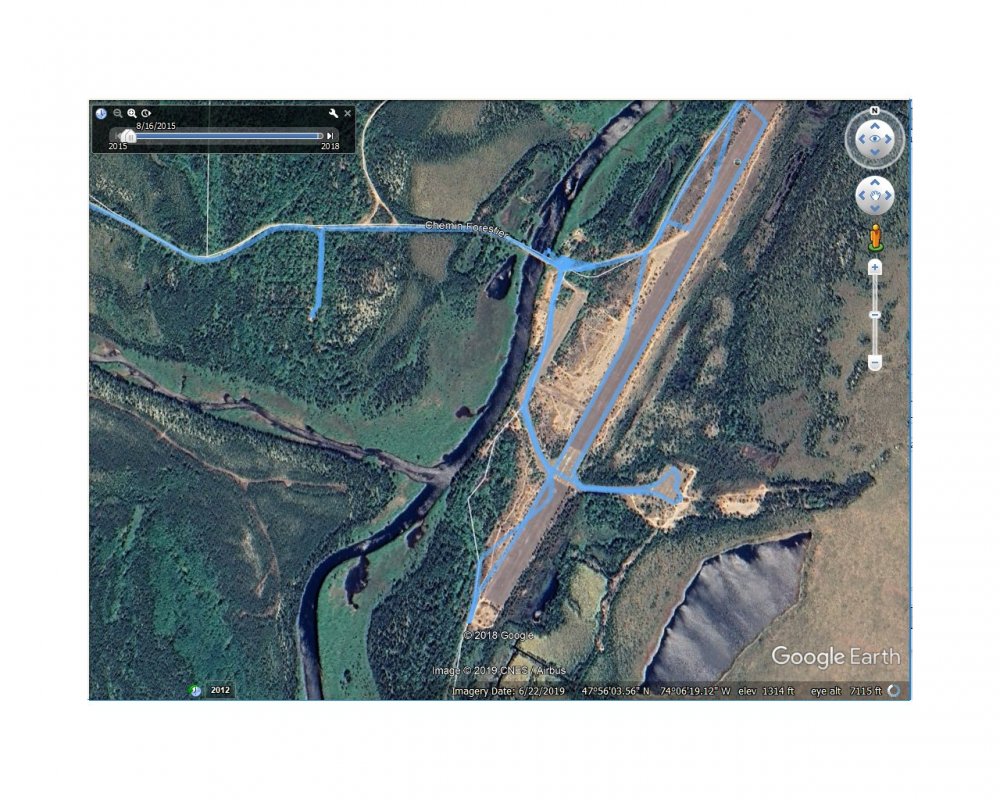
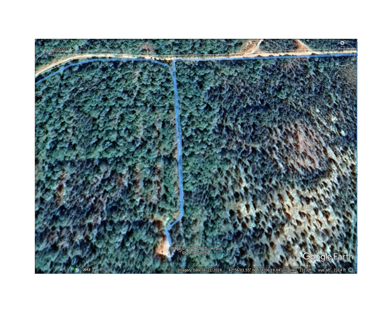
Found the coordinates of a tank. There are additional tanks, but we only went to one.
47°56'03.55N
74°06'19.04W
Will post pics of the tracks tonight
Track plots are added. Coordinates listed on bottom of image

Just what I was looking for! Thanks much!
-
8 hours ago, hparaptor said:
Give me a few days. Will look at the track for the coordinates
Thank you sir! Even a screenshot or description of sorts would help. Hoping to pass through there and wanted to snoop around some!
Thanks again!
Ike
-
Anybody happen to have coordinates for those bunkers near Casey?
Thanks.
Ike
-
Thanks. I think I got it. I think it's my computer and some settings.
-
Anyone try this recently? I just get a blank web page "box.com" when I click the link.......
On Thursday, December 21, 2017 at 9:25 PM, MrGutz said: -
-
On 11/7/2017 at 10:33 PM, Trailblazer said:
Here ya go
Thanks! I will check it out. I mostly used the i-Quad App in the Gaspe. It was very handy.
-
11 hours ago, Ike said:
X3 and Buddy's YXZ.
Not to say we didn't encounter some "tight" spots..............
-
On 10/31/2017 at 7:02 PM, hparaptor said:
Nice. What were you riding?
X3 and Buddy's YXZ.
-
-
Thanks All. I purchased the iQuad App as well. I will check into the TrakMaps.
Ikw
-
Thanks guys. Nothing out there like from Tilou et Biscuit? I don't mind buying the mapping. I have used both in the winter and prefer the Tilou. Great product! Doing the Gaspésie in September!!
Ike
-
Not to Hijack but does anyone know if there is a similar offering for Quebec for ATV trails in the Spring/Summer/Fall (non-winter season)?
Thanks
Ike
-
I cleaned all but the base files out of mine before I figured it out. I was using TrakMaps prior to this. Maiden voyage for the Tilou Biscuit mapset starts tomorrow morning!!
-
I got it! I cut and pasted the directions from the PDF (in French) into Google Translate and was able to figure it out. There are two maps in the set. The one block with the text "Sentiers Motoneige Quebec" just has the trails in it with a transparent background. If you already have a background map that you want to use, just pick that block; otherwise if you pick BOTH blocks of maps to transfer you will get their generic background map that will overlay what you already have effectively blocking out or covering your existing / preferred base map. At least this is what I've found on my Garmin Montana 650t.
Ike
-
Anyone know if the latest Tilou Biscuit Mapset can be made to use as an overlay that is transparent? It seems to block out my topo basemapping. Using Garmin Mapsource and/or Basecamp and a Garmin Montana 650t. Thanks.
Ike
-
-_- ZZZZZzzzzzzzzz................
-
http://www.toporider..._motoneige.html
I purchased trakmaps from this retailer because I wanted that handy guide.
Oh and I did verify that it's the 2013, not the 2012...they just haven't updated the site.
OK - Thanks. Just a different source than Red Pine.
Ike
(Think Snow!!)
-
The 2012-2013 GPS SledMaps are now available for Garmin GPS units!To get the newest update, first log in and then view the map you wantto update (USA or Ontario). It will be discounted based on youroriginal purchase date.We are always happy to hear feedback and help any way we can. Justemail us atThank you!-Emily and Ryan QuickRed Pine MappingLowrance Ontario is also available now. Lowrance USA is coming soon,and then Magellan for both USA and Ontario so please check back withus next week if you have Lowrance or Magellan units.
Any mapping available for Quebec from Red Pine?? Thanks.


ATV trail questions
in General Discussion
Posted
Teaser......
Yep I had to zoom up real close but ...Frost this AM at Cabanon!