scorpionbowl Posted October 26, 2010 Report Share Posted October 26, 2010 Just browsing the new 2011 Gaspe map and I see a new trail. There's always been a local [orange] trail that loops off 5 before Nouvelle, North, and down to Carleton, on the map anyway, I've never actually found the trail. This years map shows another local branch off of the top of that loop, North to 595, between 5 and LaCache. Anyone know anything about this trail? It looks like it would be well over 100 miles between gas stops... Quote Link to comment Share on other sites More sharing options...
smclelan Posted October 26, 2010 Report Share Posted October 26, 2010 Andyman and I looked at that new loop last week. You would have to double back to La Cache for sure for gas. One end of the trail starts a couple miles west of the Carleton Clubhouse. Andyman and I went part way up a couple winters ago and had to turn around because of roads being plowed for wind farm development. That should be a fantastic trail, it looks to be going right through the Fairbault (sp) area. Quote Link to comment Share on other sites More sharing options...
iceman Posted October 26, 2010 Report Share Posted October 26, 2010 Sounds interesting, I like it. Quote Link to comment Share on other sites More sharing options...
groomer Posted October 26, 2010 Report Share Posted October 26, 2010 this should be an interesting trail for the scenery specially around lac huard area.just too bad ,can t see the roads on the gaspesie map.i ve been in that area a few times ,according to the map ,trail should be up the hills and down some valleys. groomer !!! Quote Link to comment Share on other sites More sharing options...
groomer Posted October 26, 2010 Report Share Posted October 26, 2010 sorry if i use another post ,confusing a bit looking at maps.only a guess,trail could ''land '' at 84k or just around.there s not too many options in that area .mountains and valley.according to the map ,they using that road south of the ''square forks ''. iknow that area a bit ,so south of lake huard should be interesting riding. smclelan ,remember the moose on our way up gaspesie park.we were at the 88k or very close.top of the hill where we can see mount albert . according to the 2nd map again ,trail should be somewhere east of mount caribou and north of the ''go shore ''.back in the 90's i used to go on mount caribou to clean the solar panel of a telecommunication tower for the mill. third map,when you are at la cache ,going north on trail 595 ,the mountain on your left is mount noble ,all the way near lac huard.must take the roads south of lac huard to go on top. groomer !!! Quote Link to comment Share on other sites More sharing options...
groomer Posted October 26, 2010 Report Share Posted October 26, 2010 trail could be somewhere south of the 84 k.south-west of the road for nouvelle,there s a logging road going just outside escuminac. sorry for the ''sp '' errors on the other post.time to take a napt i guess !!!ha !! ha !! groomer !!! Quote Link to comment Share on other sites More sharing options...
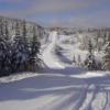
groomer Posted October 26, 2010 Report Share Posted October 26, 2010 2 pics of mount noble. first one ,coming down the hills from trail 595 toward the 100km on the truck logging road. la cache is on the extreme left of the pic. 2nd one . at the other end of mount noble ,right at the ''square forks '',90km.lac huard is not more than one mile from there if i remember well . groomer !!! Quote Link to comment Share on other sites More sharing options...
Recommended Posts
Join the conversation
You can post now and register later. If you have an account, sign in now to post with your account.