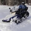
towing Posted January 9, 2012 Report Share Posted January 9, 2012 Saturday morning very cloudy -5C, Krikri our friend Snowcruiser and I began our ride from St-Zenon at La Glaciere The aim of the day is to lunch at the pourvoirie du lac Repos north of the Taureau dam. Here’ s the track of the ride: So we start on the # 350 in front of La Glaciere. The trail passes the same place as other years but trail road is plowed on the first kms up to the campsite. The road is not sanded and have a lot of snow and it runs as well as the trail. Right across from the little house that we see on the pic above, they are currently building this building. I do not know if it will be an inn or something but it look really nice... It then falls on a freshly groomed trail and it's beautiful up around the Cabanon The new trail next to the road 2 miles before arriving at the Cabanon is less beautiful with some sand mixed with snow North of the Cabanon, the first miles are snowy but thin and then when back on the wildlife Mastigouche reserve road, it is in the process of renovating it with excavators. It ride ok but it's not very nice until shortly before wildlife reserve entrance gate (about 5 miles from the Cabanon) It comes back fine then ... Further, we keep the # 345 to try the new trail and the new Mattawin river Bridge. It runs well even if it is groomed somewhat narrow on some spots for now ... to be continued... Quote Link to comment Share on other sites More sharing options...
towing Posted January 9, 2012 Author Report Share Posted January 9, 2012 the new bridge ... The river level is high and there is a trickle of water of few feet long to cross. It may look bad when we don’t know but it is solid rock below... here is what it looks like before snow ... So as long as you track in line with the bridge there’s no problem. Here’s me with the two feet in the water... There are just a few inches of water so it can be crossed well and will be bridged frozen with a bit more snow ... Next, the trail link of a couple of miles to reach the # 360 had not been groomed yet and is pretty bumpy. It then returns nice on the # 360, but even more on the # 345 to the Repos that was beautiful Past the intersection with the M20, the trail was still good. The temperature is mild and the base of the trail is not solid, more like after storm powder (even if it is not the case) Farther there was the wood cutting during the summer and we used their new road for the trail With a little more snow it will make a piece beautiful fast stretch. For now it is a bit thin but ok Quote Link to comment Share on other sites More sharing options...
towing Posted January 9, 2012 Author Report Share Posted January 9, 2012 The quick strip in the tree planting was nice The last half was groomed more recently and was nicer even though the trail base was soft ... We finally arrived for dinner at pourvoirie du Lac Repos a little past 13:00. There were alot people there! With everyone that was there, it was long just to have a place and after dinner we had to made the line-up to the gas, so we left for the return in the opposite direction around 15:00. There was obviously quite more ripple, especially in the second half of trail before the intersection with the M20, fortunately it was very dusty and the bumps were not hard. To do a bit different on our way back, we took the Taureau dam trail instead of the new bridge. The # 360 had suffered from traffic but ride well, but the south side of the bridge had suffered most, snow had swept on the sides and it was more ruff for the runners with kling-klang very common. It returned to normal past the Cabanon where dozer had resurfaced the # 23 southbound. So went back to where we started a little past 7:00 p.m. with 207 miles on the dream meter . To conclude, the snow cover of 13 "to 15" at the moment gives us acceptable trail condition but still season’s beginning conditions even it is shaping up. As you see on my pics there’s a decent cover everywhere but it’s still hard on the runners as the trail get beated on some spots. Big traffic day with mild temp as yesterday hurt more but with the efficient grooming here the trails recover quickly, many trails are daily groomed. Those who have the chance to ride over the week days will have very much better conditions because there’s at least enough snow in most of the north trails to resurface properly. We now hope for cold and more snow to improve trails and expand our playground somemore ... Alain Quote Link to comment Share on other sites More sharing options...
viper2 Posted January 9, 2012 Report Share Posted January 9, 2012 Thank's for the report and pics Alain! I was waiting for your report and it is starting to look good. Did you by chance see where the 369 is running this year. Sometimes you have to go through Repos and sometimes you can catch it off 345 near Dam Gilardo sometimes both. My father and a couple guys plan on coming up next weekend so I will show him your most recent pics. Let's hope it stays cold and gives a little snow. --Rick Quote Link to comment Share on other sites More sharing options...
towing Posted January 10, 2012 Author Report Share Posted January 10, 2012 Thank's for the report and pics Alain! I was waiting for your report and it is starting to look good. Did you by chance see where the 369 is running this year. Sometimes you have to go through Repos and sometimes you can catch it off 345 near Dam Gilardo sometimes both. My father and a couple guys plan on coming up next weekend so I will show him your most recent pics. Let's hope it stays cold and gives a little snow. --Rick It's not well marked on the trail this year but from sledder reports you take it at he Repos by going north on the road(no sand) and turning left at the stop and than 2 other miles. At the last year intersection on the #345 where we took it last year, there's no signs even there's a groomed track but I think it's the Dozer that started his run just a couple miles from there. A friend that I met at repos told me that he measured aroud 18" snow to the ground around Chateauvert area offtrail... north seems the way to go... been told no gaz at Chateauvert... Have a good trip and ride safe Alain Quote Link to comment Share on other sites More sharing options...
viper2 Posted January 10, 2012 Report Share Posted January 10, 2012 It's not well marked on the trail this year but from sledder reports you take it at he Repos by going north on the road(no sand) and turning left at the stop and than 2 other miles. At the last year intersection on the #345 where we took it last year, there's no signs even there's a groomed track but I think it's the Dozer that started his run just a couple miles from there. A friend that I met at repos told me that he measured aroud 18" snow to the ground around Chateauvert area offtrail... north seems the way to go... been told no gaz at Chateauvert... Have a good trip and ride safe Alain Thanks for the heads up on Chateavert, if that is not open with gas then you almost have to go to Repos so I suspect they will not run the old trail up through the burn from Dam Gilardo. If they have the the trail on the road leaving Repos they must not be running the log trucks through, hopefully they are not running on the river aux Rats road either then we can run the summer road all the way to Kanawata's driveway. We have done this run in the past from Le Cabanon by going down toward St. Michel and getting on the lake at the campground then off at Canadventure up 33 to Repos the road all the way to Kanawata and on to Casey all before noon. I have a couple questions maybe you can find out on the french forums 1) Did they ever finish the new road from Casey to toward Parent? The guy at Casey told us about it a couple years ago I am not sure if it comes out at Parent or further south. 2) Does anyone know if it is still possible to get to the outfitter Windigo by taking the trail right by Dam Gilardo? If you can picture where I mean it's just as you get to the dam instead of making the hard left to go around the dam this trail goes straight. I have never ventured on it but have seen some signs years ago and heard it could be done but lots of lake running. Quote Link to comment Share on other sites More sharing options...
Trailblazer Posted January 10, 2012 Report Share Posted January 10, 2012 Thanks for the heads up on Chateavert, if that is not open with gas then you almost have to go to Repos so I suspect they will not run the old trail up through the burn from Dam Gilardo. It was reported Last year Chauteauvert was closed, so when we arrived at Cabanon for our Gouin Reservoir trip le Cabanon told us there is someone there but not to depend on them as they may be out trapping or doing maintenance around the property. Regardless, the trail still split at the dam for Chauteauvert, our Yamahas got to Chauteauvert with very little gas to spare, not enough to make it to Kanawata though, so i would suggest to carry some on board if you want to do that stretch. Of course if you got one of those fume burners from BRP hell you can make there and back on a tank. 2) Does anyone know if it is still possible to get to the outfitter Windigo by taking the trail right by Dam Gilardo? If you can picture where I mean it's just as you get to the dam instead of making the hard left to go around the dam this trail goes straight. I have never ventured on it but have seen some signs years ago and heard it could be done but lots of lake running. Last year on our Gouin Reservoir trip we stopped at that corner for a break and saw sleds going through, they were carrying spare gas. Not sure about this year. Many years ago we left Relais 22 and went that way, Windigo at the time had no gas, on the otherside of the reservoir there is a campground called Coucachee and he sold gas, from there down to the dam and back to our trucks that were at Riviere Mattawan put 110 miles on my Polaris. So gas on board for that neck of the woods is a must. Quote Link to comment Share on other sites More sharing options...
viper2 Posted January 10, 2012 Report Share Posted January 10, 2012 Thanks, that shouldn't be a problem I figure with my Apex I can go about 130mi. and my wife has a vector and that can go all day so we should be good. Years ago when I had my Vmax 4 we used to make it to Chateuvert by carrying 1 gal. with and dumping it in when we got 10 or 15 miles out. I sure wish they would have designed these things with a bigger tank 9 1/2 gal. is like a step back. Quote Link to comment Share on other sites More sharing options...
towing Posted January 11, 2012 Author Report Share Posted January 11, 2012 (edited) I searched a bit but did not found information on the french forums to answer your 2 questions. The Dam Gilardo is probably this one: Krikri snap 2 pics when we crossed the bridge just after we turned left and the river from the bridge on the opposite side of the dam (she's crazy fast to snap that without stopping !!!) But I don't really care at if there was some tracks that were going straight before the bridge. For sure it was not groomed and there was no signs at all... The #369 junction was just few miles north from this dam on the #345 last year But there was no signs at all this season and we were tell to pass by the Repos.It is groomed but I think it's because the dozer is parked just a couple miles from there. If I remember right it was a 120 miles ride from Kanawata to Cabanon with last year trail... It can be really tight if you try this same path this year and have an offtrail section to do.. . I have found when shearching for your questions this pic from the #369/83 junction took around last new year day Alain Edited January 11, 2012 by towing Quote Link to comment Share on other sites More sharing options...
actionjack Posted January 11, 2012 Report Share Posted January 11, 2012 I must say you've just answered something I've wondered since I've been reading your posts.So many klicks (Km) so many photos? Krikri is taking the photos at speed! Makes perfect sense! Thanks to you both. Quote Link to comment Share on other sites More sharing options...
viper2 Posted January 11, 2012 Report Share Posted January 11, 2012 X2 Jack, I think Alain has pics of every square foot of the Lanaudiere region somewhere in his file. Thanks Alain again for the pics and the info. I know that trail probably wouldn't be groomed ever just wondering where it goes and how far it really is to Windigo. Probably now you will wonder that same thing as you pass now that I put that thought in your head. The guy that runs the groomer in that area is named Christian and he lives very close to that intersection where you said it's not marked. By car it would be off the river Rats road and if you can picture it you cross that road shortly up the trail from that intersection. That is the same road that forms part of the T from Repos toward Chateauvert. I like to try and figure out where all those roads go up there many people don't realize just how close things are to each other like Casey is to Wemotaci I think by road it is only 33 miles (and quick if it's snow covered) Quote Link to comment Share on other sites More sharing options...
zeusand Posted January 11, 2012 Report Share Posted January 11, 2012 We got gas at the Chatauvert this past sat Quote Link to comment Share on other sites More sharing options...
markusvt Posted January 11, 2012 Report Share Posted January 11, 2012 (edited) Yes, often things are much closer than they seem! Relay 22 seems like the middle of nowhere, and its 22 miles from La-Tuque by car. Edited January 11, 2012 by markusvt Quote Link to comment Share on other sites More sharing options...
viper2 Posted January 12, 2012 Report Share Posted January 12, 2012 We got gas at the Chatauvert this past sat sounds good did it seem they were prepared to be open all winter? How were the trails? Quote Link to comment Share on other sites More sharing options...
viper2 Posted January 12, 2012 Report Share Posted January 12, 2012 Yes, often things are much closer than they seem! Relay 22 seems like the middle of nowhere, and its 22 miles from La-Tuque by car. Yea and I tell ya the next time I have to go to LaTuque from Relay 22 I just may go that way. Maybe do a little welding Quote Link to comment Share on other sites More sharing options...
markusvt Posted January 12, 2012 Report Share Posted January 12, 2012 With snow, maybe the road is the way to go! We are going this week-end, will start at Matawin, head in the park and up to the Reservoir, should be nice. Yea and I tell ya the next time I have to go to LaTuque from Relay 22 I just may go that way. Maybe do a little welding Quote Link to comment Share on other sites More sharing options...
zeusand Posted January 12, 2012 Report Share Posted January 12, 2012 sounds good did it seem they were prepared to be open all winter? How were the trails? The trail's were pretty much exactly as Towing said, as far as them being open all year not sure. Very nice young guy running the place. Turned the generator on as soon as we got there and made us lunch and sold us gas Quote Link to comment Share on other sites More sharing options...
rmk Posted January 12, 2012 Report Share Posted January 12, 2012 Yea and I tell ya the next time I have to go to LaTuque from Relay 22 I just may go that way. Maybe do a little welding I cut the last 20 or so miles off most of the time by doing that you avoid all the slow areas. save a lot of time especially when your alone and it is 35 below. Funny if your behind a group and do that the look on their faces at the pump is priceless. Quote Link to comment Share on other sites More sharing options...
Recommended Posts
Join the conversation
You can post now and register later. If you have an account, sign in now to post with your account.